Oakley Green, Fifield & District Community Association
site updated -
| Home | |
| What's New & Events | |
| Community Association | |
| Communication | |
| Environment | |
| Planning | |
| Roads & Transport | |
| Local Info & Clubs | |
| Newsletters | |
| Fifield Fun Day | |
| Photo Gallery | |
| Contact Us | |
| Archive | |
| Surface Water data from the Environment Agency - 23.01.2016 | The Environment Agency provides very useful information about risks of Surface Water Flooding across the Country. Click here for explanations of how to use their maps. Or click here to go directly to their Flood Risk Maps. Enter your Post Code or Place Name. You can adjust the scale by zooming in and out with the navigation tools... the most useful is probably 1 : 10,000. Move around the map by dragging. The pull down menu next to the postcode input box allows you to look at various other available data such as rivers and infill sites etc. |
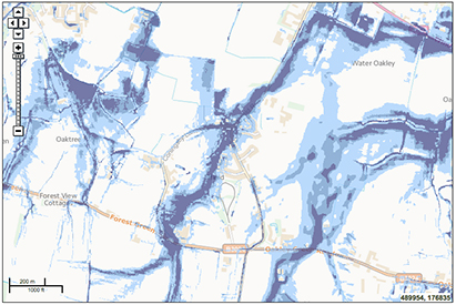 |
The image on the left is taken from the Environment Agency Surface Water Map system showing this area.
Click on the image for a larger picture. |