9 Wet Spots 2020
Where are we after 11 years ?
Where are we after 11 years ?

| ||||
| Photos | Click pic for larger image to save or print | |||
| 7b | Fifield Inn - Fifield Road (south) | |||
|
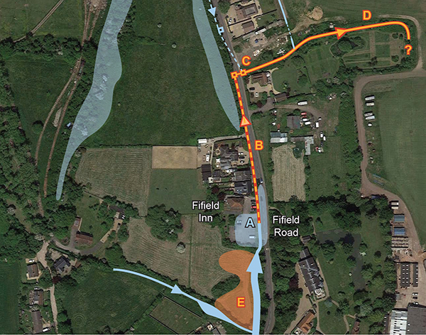
In common with many other places in the area the Fifield Inn car park (A) and Fifield Road flooded in 2001, 2003-2004, and again on Saturday 4 January 2014. But this location can flood quite frequently whenever there is a period of rainfall. In the original “9 Wet Spots” report this was included in “Wet Spot” 7 on the assumption that there were common causes and solutions with the problems further north up Fifield Road and south of Stewart Close.
At that time there was a complete misunderstanding of the very local fluid dynamics and it was assumed that all water flowing through the village was heading north trying to get to the Thames. During the Streetcare investigations in 2014 it was discovered that some water on Fifield Road actually flows SOUTH ! The common exit point for water south of Stewart Close is along a ditch heading east from (C) along the northern boundary of Garden Cottage towards (D) and the polo ground. At the end of 2014 Streetcare completed the project to address the northern part of this which has meant that “Wet Spot” 7 has been partially dealt with and has been given GREEN status. The southerly part has now been separated, renamed 7B, and still remains at RED. Water entering the ditch between the car park (A) and the road far exceeds the volume that can be accommodated by its only route north via an underground pipe (B) from the south side of the entrance to the car park heading north to the chambers at (C). A first step is clearly to ensure that this whole route, including the outflow ditch towards the polo pitch (D) is flowing freely. That may not be sufficient to deal satisfactorily with the situation so it might be necessary to investigate creating a large sump area (E) to delay extreme flows. | ||||